|
REFINE
Browse All : Images of Boulder from 1935
1-8 of 8
Title
Map of Boulder County claims along Middle Boulder Creek in Colorado
Date Issued
1935
County
Boulder
Identifier
mesc_miningMaps_43307400.jpg
Title
Map of Boulder County claims along North Boulder Creek in Colorado
Date Issued
1935
County
Boulder
Identifier
mesc_miningMaps_43307200.jpg
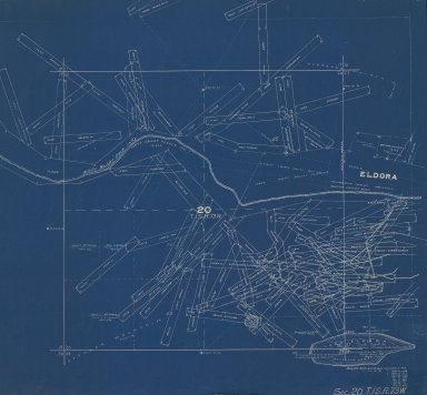
Title
Map of Boulder County claims around Middle Boulder Creek and Lake Eldora in Colorado
Date Issued
1935
County
Boulder
Identifier
mesc_miningMaps_43307500.jpg
Title
Map of Boulder County claims in Colorado
Date Issued
1935
County
Boulder
Identifier
mesc_miningMaps_43305100.jpg
Title
Map of Boulder County claims in Colorado
Date Issued
1935
County
Boulder
Identifier
mesc_miningMaps_43306300.jpg
Title
Map of the Gladys Mine and Adjoining Claims
Date Issued
1935
County
Boulder
Identifier
mesc_miningMaps_43320800.jpg
Title
Map of the Gladys Mine and adjoining claims in Sugar-Loaf Mining District
Date Issued
1935
County
Boulder
Identifier
43351500.tif
1-8 of 8
|