|
Title
Boulder County Mine
Date Issued
1942
County
Boulder
Identifier
mesc_miningMaps_43318700.jpg
Title
Bureau of mines trenches and drill holes near Rambler Shaft
Date Issued
Undated
County
Boulder
Identifier
43356501.tif
Title
Cold Spring and Orange Blossom
County
Boulder
Identifier
43377200.tif
Title
Drumm's Mining Map of Magnolia and Vicinity situated in Boulder County, Colorado
Date Issued
1905
County
Boulder
Identifier
mesc_miningMaps_43319200.jpg
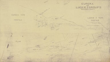
Title
Eureka and Luckie 2 Groups
Date Issued
[1950]
County
Boulder
Identifier
mesc_miningMaps_43318800.jpg
Title
Eureka, Lookout and Luckie 2 Groups
Date Issued
Undated
County
Boulder
Identifier
mesc_miningMaps_43318302.jpg
Title
Firth-Sterling Steel Co. Map of Claims and Mines north end Hurricane Hill
Date Issued
Undated
County
Boulder
Identifier
43377800.tif
Title
Gale Shaft
County
Boulder
Identifier
43376200.tif
Title
Geology of Richmond & Fairfax Mines
Date Issued
Undated
County
Boulder
Identifier
mesc_miningMaps_43320200.jpg
Title
Grand Island Mining District
County
Boulder
Identifier
43376300.tif
Title
Grand Island Mining District
County
Boulder
Identifier
43376100.tif
Title
Hummer, Hoosier, and Phillip shafts
County
Boulder
Identifier
43378000.tif
Title
Illinois and Illinois Extension
County
Boulder
Identifier
43378200.tif
Title
Illinois Mine geologic maps
County
Boulder
Identifier
43378100.tif
Title
Kicker Shaft
County
Boulder
Identifier
43375900.tif
Title
Kicker, Star, Lastchance, Tenderfoot Mines
County
Boulder
Identifier
43377300.tif
Title
Lily Tunnel, Gale Shaft, Clyde Mine
County
Boulder
Identifier
43377400.tif
Title
Location Map of the Boulder County Tungsten District
Date Issued
1944
County
Boulder
Identifier
mesc_miningMaps_43320100.jpg
Title
Longitudinal section of the Golden Age Mine
Date Issued
1930
County
Boulder
Identifier
43355400.tif
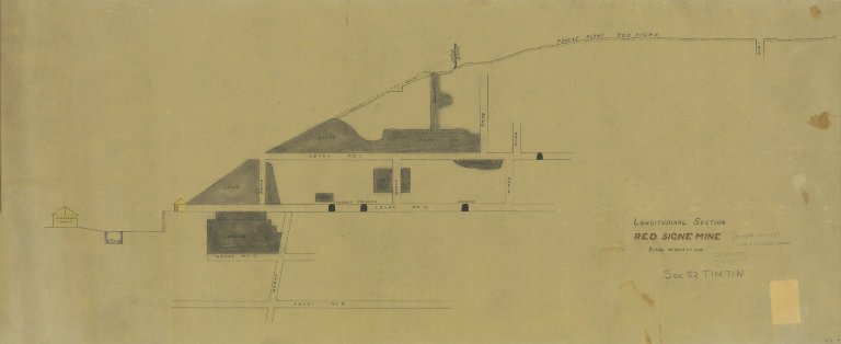
Title
Longitudinal section Red Signe Mine
County
Boulder
Identifier
mesc_miningMaps_43320500.jpg
Title
Longitudinal section, Cold Spring Mine
Date Issued
1929
County
Boulder
Identifier
43356000.tif
Title
Madeline, Cross, and Firth Mines
County
Boulder
Identifier
43377500.tif
Title
Map of Black Jack Tunnel, Jack and Summit, Cross No. 2 Tunnel, New York and Philadelphia Shafts, Pansy Blossom, Spencer Tunnel, and Carlberg
Date Issued
[1944]
County
Boulder
Identifier
43377700.tif
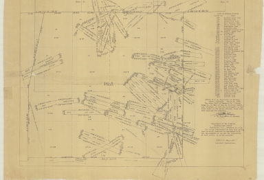
Title
Map of Boulder County and Gilpin County claims in Colorado
Date Issued
1928
County
Boulder
Identifier
mesc_miningMaps_43307300.jpg
Title
Map of Boulder County claims
Date Issued
1916
County
Boulder
Identifier
43348500.tif
Title
Map of Boulder County claims
Date Issued
1917
County
Boulder
Identifier
mesc_miningMaps_43367100.tif
Title
Map of Boulder County claims
Date Issued
1927-03-27/1930-02-19
County
Boulder
Identifier
43357500.tif
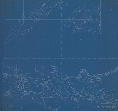
Title
Map of Boulder County claims
Date Issued
1928
County
Boulder
Identifier
maps_coHistorical_1928_wardSect6TINR72W_d.jpg
Title
Map of Boulder County claims along east slope of Bald Mountain in Colorado
Date Issued
1932
County
Boulder
Identifier
mesc_miningMaps_43317600.jpg
Title
Map of Boulder County claims along Farwell Gulch in Colorado
Date Issued
1932
County
Boulder
Identifier
mesc_miningMaps_43304700.jpg
Title
Map of Boulder County claims along Four Mile Creek in Colorado
Date Issued
1920
County
Boulder
Identifier
mesc_miningMaps_43319500.jpg
Title
Map of Boulder County claims along Gordon Gulch in Colorado
Date Issued
1932
County
Boulder
Identifier
mesc_miningMaps_43305000.jpg
Title
Map of Boulder County claims along Gordon Gulch in Colorado
Date Issued
1932
County
Boulder
Identifier
mesc_miningMaps_43305700.jpg
Title
Map of Boulder County claims along Left Hand Creek in Colorado
Date Issued
1928
County
Boulder
Identifier
mesc_miningMaps_43306600.jpg
Title
Map of Boulder County claims along Middle Boulder Creek in Colorado
Date Issued
1925
County
Boulder
Identifier
mesc_miningMaps_43303900.jpg
Title
Map of Boulder County claims along Middle Boulder Creek in Colorado
Date Issued
1925
County
Boulder
Identifier
mesc_miningMaps_43306000.jpg
Title
Map of Boulder County claims along Middle Boulder Creek in Colorado
Date Issued
1935
County
Boulder
Identifier
mesc_miningMaps_43307400.jpg
Title
Map of Boulder County claims along North Boulder Creek
Date Issued
1915
County
Boulder
Identifier
mesc_miningMaps_43320900.jpg
Title
Map of Boulder County claims along North Boulder Creek in Colorado
Date Issued
1928
County
Boulder
Identifier
mesc_miningMaps_43306100.jpg
Title
Map of Boulder County claims along North Boulder Creek in Colorado
Date Issued
1935
County
Boulder
Identifier
mesc_miningMaps_43307200.jpg
Title
Map of Boulder County claims around Four Mile Creek in Colorado
Date Issued
1917
County
Boulder
Identifier
mesc_miningMaps_43319300.jpg
Title
Map of Boulder County claims around Hicks Gulch in Colorado
Date Issued
1932
County
Boulder
Identifier
mesc_miningMaps_43303700.jpg
Title
Map of Boulder County claims around Left Hand Fork in Colorado
Date Issued
1932
County
Boulder
Identifier
mesc_miningMaps_43305600.jpg
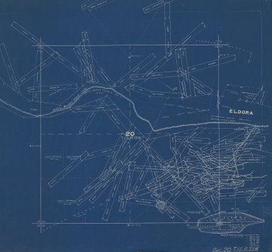
Title
Map of Boulder County claims around Middle Boulder Creek and Lake Eldora in Colorado
Date Issued
1935
County
Boulder
Identifier
mesc_miningMaps_43307500.jpg
Title
Map of Boulder County claims around Middle Boulder Creek in Colorado
Date Issued
1932
County
Boulder
Identifier
mesc_miningMaps_43307000.jpg
Title
Map of Boulder County claims around Park Creek in Colorado
Date Issued
1932
County
Boulder
Identifier
mesc_miningMaps_43317800.jpg
Title
Map of Boulder County claims around Porphyry Mountain in Colorado
Date Issued
1928
County
Boulder
Identifier
mesc_miningMaps_43305500.jpg
Title
Map of Boulder County claims in Colorado
Date Issued
1916
County
Boulder
Identifier
mesc_miningMaps_43306200.jpg
Title
Map of Boulder County claims in Colorado
Date Issued
1919
County
Boulder
Identifier
mesc_miningMaps_43319600.jpg
|