|
Title
Placer claim of E. L. Hubbard
Date Issued
Undated
County
Boulder
Identifier
mesc_miningMaps_43366600.tif
Title
Map showing Chingis Kahn group of mining claims
Date Issued
1907
County
Boulder
Identifier
43367000.tif
Title
Map of White Placer along Boulder Creek in Colorado
County
Boulder
Identifier
mesc_miningMaps_43319800.jpg
Title
Map of the Lincoln Group
Date Issued
1934
County
Boulder
Identifier
mesc_miningMaps_43318600.jpg
Title
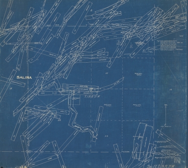
Map of Stone and Timber claim and White placer in Boulder County, Colorado
County
Boulder
Identifier
mesc_miningMaps_43320700.jpg
Title
Map of Boulder County claims in Colorado
Date Issued
1928
County
Boulder
Identifier
mesc_miningMaps_43304500.tif
Title
Map of Boulder County claims in Colorado
Date Issued
1928
County
Boulder
Identifier
mesc_miningMaps_43305800.jpg
Title
Map of Boulder County claims in Colorado
Date Issued
1928
County
Boulder
Identifier
mesc_miningMaps_43305900.jpg
Title
Map of Boulder County claims in Colorado
Date Issued
1928
County
Boulder
Identifier
mesc_miningMaps_43319400.jpg
Title
Map of Boulder County claims in Colorado
Date Issued
1932
County
Boulder
Identifier
mesc_miningMaps_43303600.jpg
Title
Map of Boulder County claims in Colorado
Date Issued
1932
County
Boulder
Identifier
mesc_miningMaps_43304900.jpg
Title
Map of Boulder County claims in Colorado
Date Issued
1935
County
Boulder
Identifier
mesc_miningMaps_43305100.jpg
Title
Map of Boulder County claims in Colorado
Date Issued
[1919]
County
Boulder
Identifier
mesc_miningMaps_43321300.jpg
Title
Map of Boulder County claims around Four Mile Creek in Colorado
Date Issued
1917
County
Boulder
Identifier
mesc_miningMaps_43319300.jpg
Title
Map of Boulder County claims along Middle Boulder Creek in Colorado
Date Issued
1925
County
Boulder
Identifier
mesc_miningMaps_43303900.jpg
Title
Map of Boulder County claims along Left Hand Creek in Colorado
Date Issued
1928
County
Boulder
Identifier
mesc_miningMaps_43306600.jpg
Title
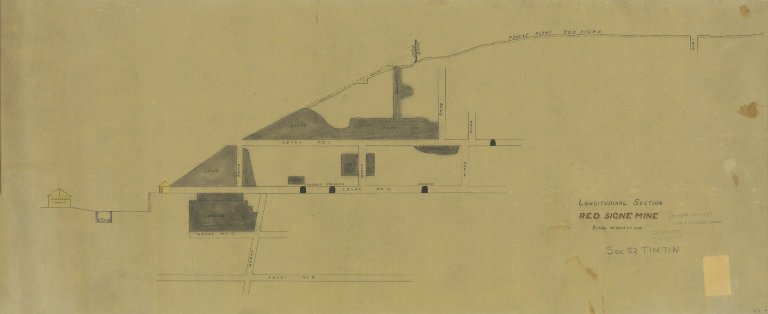
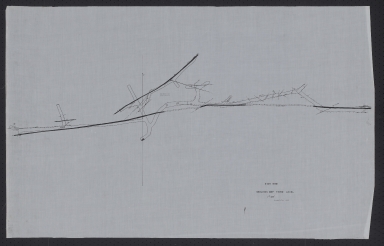
Longitudinal section Red Signe Mine
County
Boulder
Identifier
mesc_miningMaps_43320500.jpg
Title
Boulder County Mine
Date Issued
1942
County
Boulder
Identifier
mesc_miningMaps_43318700.jpg
Title
Workings of Richmond & Fairfax Mines
County
Boulder
Identifier
mesc_miningMaps_43320300.jpg
Title
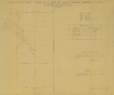
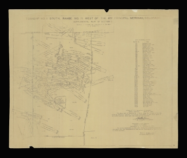
Township no. 1 south, range no. 71 west of the 6th principal meridian, Colorado
Date Issued
1930
County
Boulder
Identifier
mesc_miningMaps_43321500.jpg
Title
Township No. 1 south, range No. 71 west of the 6th principal meridian, Colorado
Date Issued
1930
County
Boulder
Identifier
mesc_miningMaps_43357400.tif
Title
Township No. 1 south, range No. 71 west of the 6th principal meridian, Colorado
Date Issued
1930
County
Boulder
Identifier
43355100.tif
Title
Tenderfoot Shaft
Date Issued
1944
County
Boulder
Identifier
43377900.tif
Title
Sugar Loaf Mining District
Date Issued
Undated
County
Boulder
Identifier
mesc_miningMaps_43321400.jpg
Title
Star Mine
Date Issued
1943
County
Boulder
Identifier
43377601.tif
Title
Star Mine
Date Issued
1943
County
Boulder
Identifier
43377602.tif
Title
Star Mine
Date Issued
1943
County
Boulder
Identifier
43377603.tif
Title
Star Mine
Date Issued
1943
County
Boulder
Identifier
43377604.tif
Title
Rambler Mine
Date Issued
Undated
County
Boulder
Identifier
43356502.tif
Title
Pueblo Belle and adjacent workings
County
Boulder
Identifier
mesc_miningMaps_43372100.tif
Title
Prospect Tunnel Under Hurricane Hill
Date Issued
[1944]
County
Boulder
Identifier
43377100.tif
Title
Plat of Time Tunnel and Wynona Lode
Date Issued
1936
County
Boulder
Identifier
mesc_miningMaps_43304300.jpg
Title
Plat of the oil lands of Longmont Oil Coal and Gas Development Co.
Date Issued
Undated
County
[Boulder, Weld]
Identifier
Longmont Oil Platt.tif
Title
Plat of the Claim of C.H. Pate
Date Issued
1905
County
Boulder
Identifier
mesc_miningMaps_43321801.jpg
Title
Plat of Sections 14, 15, 22 & 23 T.1S.R.73W. of the 6th P.M.
Date Issued
Undated
County
Boulder
Identifier
mesc_miningMaps_43307100.jpg
Title
Plat of Cripple Creek District Railroad
Date Issued
Undated
County
Boulder
Identifier
43353100.tif
Title
Plan map showing workings of the Fairfax, Minneapolis, and Mineral Point claims
Date Issued
1935
County
Boulder
Identifier
mesc_miningMaps_43351400.tif
Title
Plan map of Fairfax, Minneapolis and Mineral Point claims
County
Boulder
Identifier
mesc_miningMaps_43365700.tif
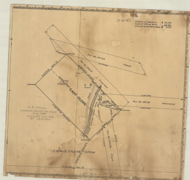
Title
Mining claims near the Golden Age Lode
Date Issued
1934
County
Boulder
Identifier
mesc_miningMaps_43317700.jpg
Title
Mineral survey No. 20605
Date Issued
[1939]
County
Boulder
Identifier
43353000.tif
Title
Map showing survey at Fairfax Mine
Date Issued
1936
County
Boulder
Identifier
mesc_miningMaps_43320600.jpg
Title
Map Showing Properties of Firth Sterling Steel and Carbide Corporation
Date Issued
1949
County
Boulder
Identifier
mesc_miningMaps_43319000.jpg
Title
Map showing Pennsylvania and Roosevelt claims
Date Issued
Undated
County
Boulder
Identifier
mesc_miningMaps_43369500.tif
Title
Map showing location of the Alton Tunnel mining property
Date Issued
1931
County
Boulder
Identifier
mesc_miningMaps_43320400.jpg
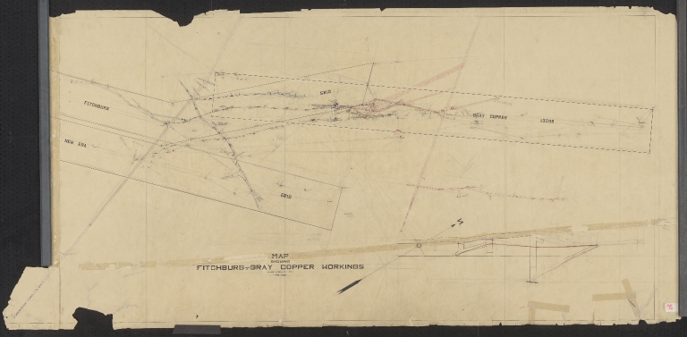
Title
Map showing Fitchburg-Gray copper workings
Date Issued
1936
County
Boulder
Identifier
43375501.tif
Title
Map showing Fitchburg-Gray copper workings
Date Issued
1936
County
Boulder
Identifier
43375502.tif
Title
Map of tunnel plans for Boulder County mines
Date Issued
Undated
County
Boulder
Identifier
43353200.tif
Title
Map of topographical features over mine claims in Boulder County
Date Issued
Undated
County
Boulder
Identifier
43375700.tif
Title
Map of the Gladys Mine and adjoining claims in Sugar-Loaf Mining District
Date Issued
1935
County
Boulder
Identifier
43351500.tif
|