|
Title
[Township no. 1 South, Range no. 71 West of the 6th Principal Meridian]
Title
[Township no. 1 South, Range no. 71 West of the 6th Principal Meridian] : [Boulder County, Colorado]
Name Display Form
[Boulder County (Colo.). County Planning Commission., Porreca, Vincent J., Boulder (Colo.). City Planning Board.]
Title
A plan for the Boulder Valley
Date Issued
1969
Name Display Form
[Boulder County (Colo.). County Planning Commission., Porreca, Vincent J., Boulder (Colo.). City Planning Board.]
Title
A plan for the Boulder Valley
Date Issued
1969
Name Display Form
[Davis, L. W., March, Edward R., Byler, E. A., Jonathan W. Proudfit & Company]
Title
Approved mineral surveys in the Cripple Creek Mining District, Teller County, formerly Fremont and El Paso Counties, Colorado
Date Issued
1900
Name Display Form
[Clason, George S. (George Samuel), 1874-1957, Clason Map Co.]
Title
Approved mineral surveys of the principal mining districts in Boulder County, Colorado
Date Issued
1916
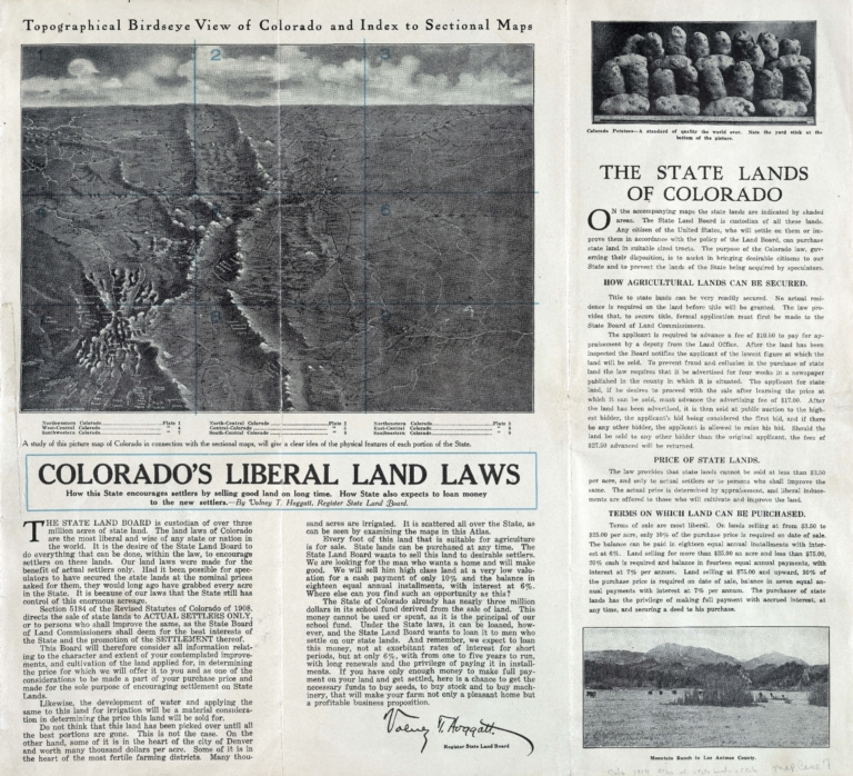
Title
Atlas of the state lands of Colorado
Date Issued
1914
Name Display Form
[Warner, Higgins & Beers., Warner & Beers., H.H. Lloyd & Co.]
Title
Atlas of the United States : map of Utah, Arizona, New Mexico, Kansas, Colorado and Indian Territory
Date Issued
[1872]
Name Display Form
[Raine, William MacLeod, 1871-1954, Clatworthy, Fred Payne, 1875-1953, McClure, Louis Charles, 1867-1957]
Title
Beautiful Estes Park: one of Colorado's most popular summer resorts
Date Issued
1912
Name Display Form
Vander Sluis, George, 1915-1984, cartographer
Title
Being a map of the Pikes Peak region showing facts, fables, fancies
Date Issued
[1947]
Name Display Form
Geological Survey (U.S.)
Title
Bird's eye map of Colorado showing tourists' resorts
Date Issued
[1919]
Name Display Form
[United States. Forest Service, Greeley, William B., 1879-1955, Kuphal, H. H., compiler]
Title
Cochetopa National Forest, Colorado : New Mexico principal meridian
Name Display Form
[United States. Forest Service, Greeley, William B., 1879-1955, Kuphal, H. H., compiler]
Title
Cochetopa National Forest, Colorado : New Mexico principal meridian
Name Display Form
Geographical Publishing Co.
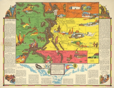
Title
Colorado
Date Issued
1920/[1929]
Name Display Form
[Aitchison, R. T. (Robert T.), 1887-1964, Mentholatum Company]
Title
Colorado, the centennial state
Date Issued
1938
Name Display Form
Estes Park Conference
Title
Detail map of the Estes Park Conference Association Camp, Colorado
Date Issued
[between 1970 and 1979]
Name Display Form
Estes Park Conference
Title
Detail map of the Estes Park Conference Association Camp, Colorado
Date Issued
[between 1970 and 1979]
Name Display Form
Drumm, Henry A., 1857-1937, cartographer
Title
Drumm's pocket map of Boulder County Colorado
Date Issued
1906
Name Display Form
[Johnston, Nik, cartographer, McDonald's Corporation., Bernstein/Rein & Boasberg Advertising]
Title
Family fun places
Date Issued
1973
Name Display Form
Glover, E. S. (Eli Sheldon), 1844-1920
Title
Glover's birds eye view of Denver, Colorado, 1874
Date Issued
1874
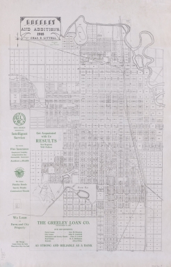
Title
Greeley and additions
Date Issued
1916
Name Display Form
North Gunnison Land and Stone Quarry Co
Title
Gunnison : North Gunnison and environs [Colorado]
Date Issued
[1885]
Name Display Form
North Gunnison Land and Stone Quarry Co
Title
Gunnison : North Gunnison and environs [Colorado]
Date Issued
[1885]
Title
Gunnison county, Colorado
Date Issued
[between 1891 and 1908]
Name Display Form
[Highway Map Co., Blauvelt, D. L]
Title
Highway map of Colorado
Date Issued
[1930]
Name Display Form
[Highway Map Co., Blauvelt, D. L]
Title
Highway map of Colorado
Date Issued
[1930]
Name Display Form
Willits, W. C. (Warren C.), 1847-1901
Title
Map of Boulder Colorado
Date Issued
1887
Name Display Form
[Cannon, R. M., cartographer, Davis, E. G., Hennigar, A. G.]
Title
Map of Colorado Springs, Colorado City and vicinity
Date Issued
1895
Name Display Form
[Hafen, LeRoy R. (LeRoy Reuben), 1893-1985, Clason Map Co.]
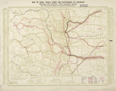
Title
Map of early trails, forts and battlefields of Colorado : prepared for Municipal Facts Magazine, Denver
Date Issued
[1925]
Name Display Form
[Hafen, LeRoy R. (LeRoy Reuben), 1893-1985, Clason Map Co.]
Title
Map of early trails, forts and battlefields of Colorado : prepared for Municipal Facts Magazine, Denver
Date Issued
[1925]
Name Display Form
[Clark, W. H. (William H.), 1857- compiler., Monroe, F. P., compiler, Trumbor, W. H., compiler, Clark, Monroe & Trumbor]
Title
Map of Garfield County, Colo.
Date Issued
[1888]
Name Display Form
[Clark, W. H. (William H.), 1857- compiler., Monroe, F. P., compiler, Trumbor, W. H., compiler, Clark, Monroe & Trumbor]
Title
Map of Garfield County, Colo.
Date Issued
[1888]
Title
Map of Georgetown, Clear Creek County, Colorado
Date Issued
[between 1875 and 1880]
Title
Map of mining claims of the Chrysolite Silver Mining Co. : Fryer Hill, Leadville, Col.
Date Issued
[1879]
Name Display Form
Drumm, Henry A., 1857-1937
Title
Map of the lands of the Consolidated Oil Company : and of other companies in which the Consolidated Oil Company has either large or controlling interests : [Boulder County, Colorado]
Date Issued
[between 1902 and 1909?]
Name Display Form
Colorado Coal and Iron Company.
Title
Map showing property of the Colorado Coal & Iron Company
Date Issued
[1889]
Name Display Form
Colorado Coal and Iron Company.
Title
Map showing property of the Colorado Coal & Iron Company
Date Issued
[1889]
Name Display Form
United States. National Park Service
Title
Mesa Verde National Park, Colorado
Date Issued
[1973]
Name Display Form
United States. National Park Service
Title
Mesa Verde National Park, Colorado
Date Issued
[1973]
Name Display Form
United States. National Park Service
Title
Mesa Verde National Park, Colorado
Date Issued
[1999]
Name Display Form
United States. National Park Service
Title
Mesa Verde National Park, Colorado
Date Issued
[1999]
Name Display Form
Geological Survey (U.S.)
Title
Plan, Colorado River, Rifle to Glenwood Springs, Colorado, dam site
Date Issued
1951
Name Display Form
Geological Survey (U.S.)
Title
Plan, Colorado River, Rifle to Glenwood Springs, Colorado, dam site
Date Issued
1951
Name Display Form
Prather, Ralph Carlyle
Title
Prather's aerial view of the Rocky Mountain National, Estes, Park [Colorado]
Date Issued
1922
Title
Preliminary guide for growth : Boulder and vicinity
Date Issued
[1956]
Title
Preliminary guide for growth : Boulder and vicinity
Date Issued
[1956]
Title
Profile of Prospect St. between Vermijo Ave. & Moreno Ave., Colorado Springs, Colo.
Date Issued
1902
Name Display Form
Peach, Wm., 1861-
Title
Pueblo County, Colorado : compiled from actual surveys and the official records
Date Issued
1927
Name Display Form
Peach, Wm., 1861-
Title
Pueblo County, Colorado : compiled from actual surveys and the official records
Date Issued
1927
|
![[Township no. 1 South, Range no. 71 West of the 6th Principal Meridian]](https://cudl.colorado.edu/MediaManager/srvr?mediafile=/Size3/CUB~13~13/4997/maps_coHistorical_southBoulderCreekSect_1888_B_d.jpg)
![[Township no. 1 South, Range no. 71 West of the 6th Principal Meridian] : [Boulder County, Colorado]](https://cudl.colorado.edu/MediaManager/srvr?mediafile=/Size3/CUB~13~13/4997/maps_coHistorical_southBoulderCreekSect_1888_A_d.jpg)


![Gunnison : North Gunnison and environs [Colorado]](https://cudl.colorado.edu/MediaManager/srvr?mediafile=/Size1/CUB~13~13/5018/maps_coHistorical_northGunnisonEnvirons_1885_B_d.jpg)
![Gunnison : North Gunnison and environs [Colorado]](https://cudl.colorado.edu/MediaManager/srvr?mediafile=/Size1/CUB~13~13/5018/maps_coHistorical_northGunnisonEnvirons_1885_A_d.jpg)


![Map of the lands of the Consolidated Oil Company : and of other companies in which the Consolidated Oil Company has either large or controlling interests : [Boulder County, Colorado]](https://cudl.colorado.edu/MediaManager/srvr?mediafile=/Size2/CUB~13~13/4709/maps_coHistorical_consolidatedOil1873.jpg)


![Prather's aerial view of the Rocky Mountain National, Estes, Park [Colorado]](https://cudl.colorado.edu/MediaManager/srvr?mediafile=/Size3/CUB~13~13/4711/maps_coHistorical_prathersRMN1922.jpg)


