COLLECTION NAME:
Mining Maps of Colorado
Record
Collection Name:
Mining Maps of Colorado
Title:
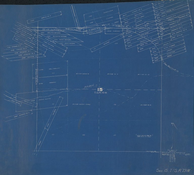
Map of Boulder County claims around Hicks Gulch in Colorado
Alternative Title:
Revised map drawn from records of U.S. Survey General, Denver
State:
Colorado
County:
Boulder
USGS Quadrangle:
Nederland
Name:
Drumm, Henry A., 1857-1937
Name Role Term Text:
Cartographer
Type of Resource:
cartographic image
Genre:
Maps
Place Term:
Boulder (Colo.)
Publisher:
Henry A. Drumm, Maps
Date Issued:
1932
Date Created:
1917-03-10/1932-07-23
Language Term:
English
Form:
Cartographic materials
Internet Media Type:
image/jpeg
Extent:
1 map : blueprint ; 62 x 72 cm
Digital Origin:
reformatted digital
Mine Note:
Chicago (placer), The Cardinal (mine shaft), O. & M. (mine shaft), The Boulder County (mine shaft), Paradice, Well Margaret
Commodity Note:
Gold
Note:
Shows plots of land belonging to Central Colorado Power Co., M. A. Tucker Investment Co.
Subject Topic:
Mines and mineral resources
Scale:
1" = 300'
Coordinates:
39° 57' 52.2'' N / 105° 32' 56.76'' W
Meridian:
6th
Public Land Survey Location:
Sec.15, T.1S.R.73W.
Subject Topic:
Mines and mineral resources -- Colorado -- Boulder County
Subject Authority:
local
Identifier:
mesc_miningMaps_43303700.jpg
Physical Location:
Jerry Crail Johnson Earth Sciences & Map Library, University of Colorado Boulder
Shelf Identifier:
344
Rights:
This Item is protected by copyright and/or related rights. You are free to use this Item in any way that is permitted by the copyright and related rights legislation that applies to your use. For other uses you need to obtain permission from the rights-holder(s).
Map of Boulder County claims around Hicks Gulch in Colorado