COLLECTION NAME:
Bent-Hyde Papers
Record
File Name:
arbh03m1.tif
Collection Name:
Bent-Hyde Papers, 1905-1918
Collection Description:
This collection consists of original maps detailing locations of Indigenous nations in North America and military positions in areas such as Sand Creek and the Arkansas River. It includes correspondence between George Bent, a Cheyenne-American interpreter, George Hyde, a white historian, and George Grinnell, a white anthropologist while covering the years 1905-1918. In the interest of preserving and presenting the historical records, the University Libraries collects materials that document the perspectives presented by the creators. As a result, this collection contains objectionable depictions and language that do not reflect the current preferred terminology, or the values and norms of the University Libraries. CU Boulder Libraries acknowledges that it is located on the traditional territories and ancestral homelands of the Cheyenne, Arapaho, Ute and many other Native American nations. Their forced removal from these territories has caused devastating and lasting impacts. While the University of Colorado Boulder can never undo or rectify the devastation wrought on Indigenous peoples, we commit to improving and enhancing engagement with Indigenous peoples and issues locally and globally.
Work Title:
Bent's Old Fort, Sand Creek Trail
Alternative Title:
Map #6 Location of Indian trails
Alternative Title Type:
proper (transcribed from "Fourteen original maps of George Bent and George Hyde by Jean Afton")
Work Agent Name:
Bent, George, 1843-1918
Work Agent Role:
author
Work Agent Name:
Hyde, George E., 1882-1968
Work Agent Role:
author
Work Date:
1905/1918
Work Date Type:
creation
Inscription Text:
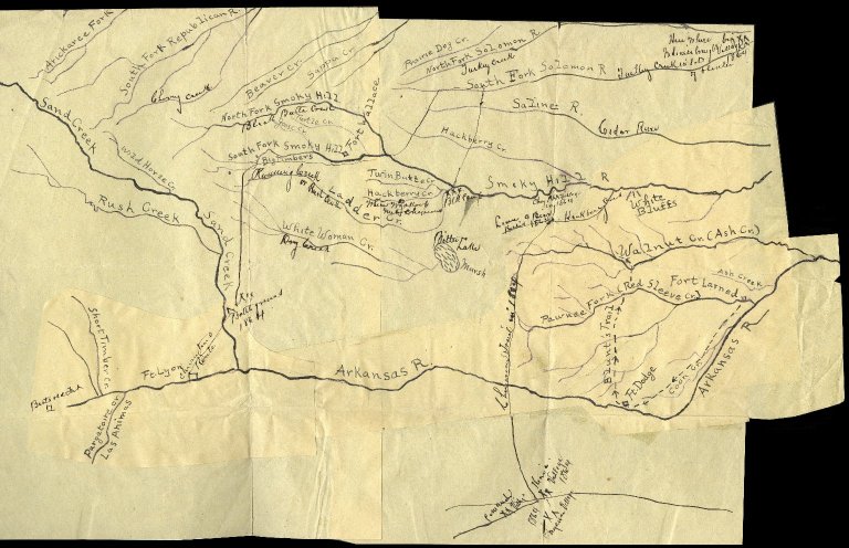
[Cataloger's note: Transcriptions come from a variety of resouces including legacy archival description and George Hyde's and George Grinnell's notes as documented by Jean Afton.] George Bent has marked on this map in his own hand: Bent's Old Fort, the trail from Fort Lyon to Sand Creek (labeled "Battle ground, 1864" as Sand Creek). The trail continues to the head of the Smoky Hill River where the Indigenous people camped after the Sand Creek attack. The trail then crosses the Smoky Hill at forks and goes to the Solomon Fork. On this stream, he notes, "big Village Here--Indigenous people brought in a lot of plunder 1864." A trail runs from Solomon to the mouth of Hackberry Creek on the Smoky Hill. Here he marks "BlK Camp" (Black Kettle's camp at the time Wynkoop came out). Further west of Hackberry, he marks where Wynkoop came for prisoners. Lower down the Smoky Hill, he marks a Cheyenne village in 1864, identified as Lean Bear's village. South of it, he marks where Lean Bear was killed by Colorado troops under Lieutenant Ayre. He also marks a trail running south from the Smoky Hill to a stream south of the Arkansas River and notes the Indigenous village there (May-June 1864: the Indigenous people were in these camps when Colonel Bent came to Fort Larned and tried to induce them to surrender). Additionally, he marks the Indigenous names of many streams.
Subject Term:
Cheyenne Nation--History--Sources
Subject Term:
Tsistsistas--History--Sources
Subject Term:
Indigenous peoples--Colorado--Maps
Subject Term:
Bent's Fort (Colo.) -- History -- Maps
Subject Term:
Sand Creek Massacre, Colo., 1864 -- Maps
Subject Term:
Cheyenne Nation--Wars, 1864
Subject Term:
Colorado--History--To 1876--Maps
Work Description:
Drawing of the Arkansas River area, Sand Creek, Fort Lyon, Fort Dodge, Fort Larned, Fort Wallace, Blunt's Trail, and Smoky Hill.
Work Type:
sketch maps
Work Type:
Cartographic
Relation:
Fourteen Original Maps of George Bent and George Hyde by Jean Afton
Relation Type:
references
Relation Identifier:
arbh23.pdf
Location Name:
University of Colorado Boulder Libraries Rare and Distinctive Collections
Location Type:
repository
Shelf Location:
Box 1 Folder 3
Image Rights:
The organization that has made the Item available believes that the Item is in the Public Domain under the laws of the United States, but a determination was not made as to its copyright status under the copyright laws of other countries. The Item may not be in the Public Domain under the laws of other countries. Please refer to the organization that has made the Item available for more information. URI: http://rightsstatem…
Image Source:
CU Boulder Online Finding Aid of Bent-Hyde Papers, 1820-1918
Image Measurement:
215000000
Image Measurement Type:
fileSize
Image Measurement Unit:
bytes
Image Work Type:
reformatted digital
Bent's Old Fort, Sand Creek Trail