|
Name Display Form
[Glover, E. S. (Eli Sheldon), 1844-1920, cartographer., Strobridge & Co. Lith.]
Title
Glover's birds eye view of Denver, Colorado, 1874
Date Issued
[1874]
Name Display Form
[Glover, E. S. (Eli Sheldon), 1844-1920, cartographer., Strobridge & Co. Lith.]
Title
Glover's birds eye view of Denver, Colorado, 1874
Date Issued
[1874]
Name Display Form
[Rome, Richardson, cartographer, Rocky Mountain Motor Company]
Title
Rocky Mountain National Park
Date Issued
[1948]
Title
[Township no. 1 South, Range no. 71 West of the 6th Principal Meridian]
Title
[Township no. 1 South, Range no. 71 West of the 6th Principal Meridian] : [Boulder County, Colorado]
Name Display Form
[Boulder County (Colo.). County Planning Commission., Porreca, Vincent J., Boulder (Colo.). City Planning Board.]
Title
A plan for the Boulder Valley
Date Issued
1969
Name Display Form
[Boulder County (Colo.). County Planning Commission., Porreca, Vincent J., Boulder (Colo.). City Planning Board.]
Title
A plan for the Boulder Valley
Date Issued
1969
Name Display Form
[Davis, L. W., March, Edward R., Byler, E. A., Jonathan W. Proudfit & Company]
Title
Approved mineral surveys in the Cripple Creek Mining District, Teller County, formerly Fremont and El Paso Counties, Colorado
Date Issued
1900
Name Display Form
[Clason, George S. (George Samuel), 1874-1957, Clason Map Co.]
Title
Approved mineral surveys of the principal mining districts in Boulder County, Colorado
Date Issued
1916
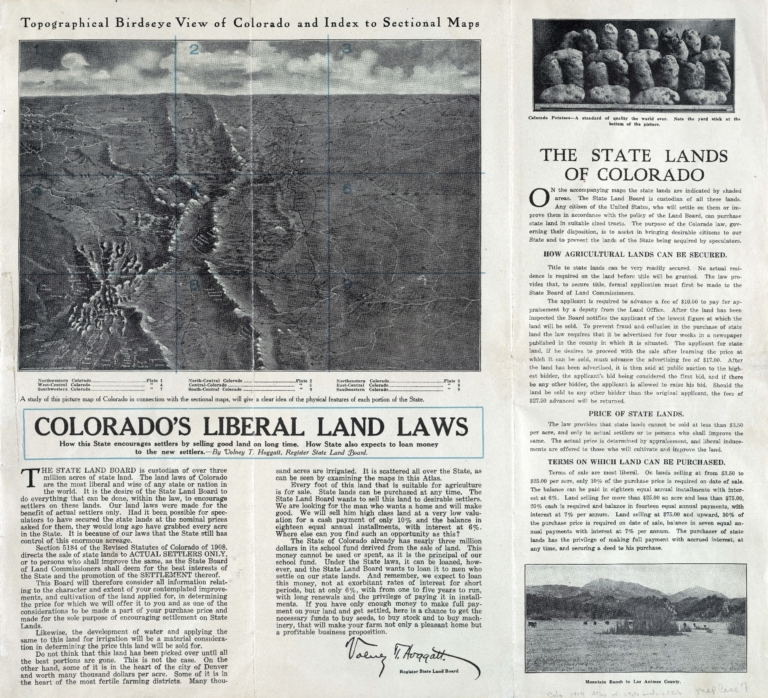
Title
Atlas of the state lands of Colorado
Date Issued
1914
Name Display Form
[Warner, Higgins & Beers., Warner & Beers., H.H. Lloyd & Co.]
Title
Atlas of the United States : map of Utah, Arizona, New Mexico, Kansas, Colorado and Indian Territory
Date Issued
[1872]
Title
Baldwin's map of mining claims near Leadville, California Mining District, Lake Co. Colorado
Date Issued
1879
Name Display Form
[Raine, William MacLeod, 1871-1954, Clatworthy, Fred Payne, 1875-1953, McClure, Louis Charles, 1867-1957]
Title
Beautiful Estes Park: one of Colorado's most popular summer resorts
Date Issued
1912
Name Display Form
Vander Sluis, George, 1915-1984, cartographer
Title
Being a map of the Pikes Peak region showing facts, fables, fancies
Date Issued
[1947]
Name Display Form
Colorado. Office of the State Engineer
Title
Biennial report of the State Engineer of the State of Colorado for the years
Name Display Form
Geological Survey (U.S.)
Title
Bird's eye map of Colorado showing tourists' resorts
Date Issued
[1919]
Name Display Form
Denver Lith. Co.
Title
Boulder
Date Issued
After 1894
Name Display Form
Freeze, Sam'l (Samuel)
Title
Boulder Co., Colorado
Date Issued
[1881]
Title
Boulder oil fields, Colorado
Date Issued
[1902]
Title
Broadmoor
Date Issued
[between 1890 and 1902?]
Name Display Form
Boehmer, Max
Title
Bœhmer's topographical map of the carbonate regions in the vicinity of Leadville, Colorado : showing location of mines and prominent prospects from actual surveys made in October 1879
Date Issued
1879
Name Display Form
Hunter, Thomas (Lithographer)
Title
Cannon's map of the mineral belt of Colorado
Date Issued
Approximately 1882
Name Display Form
Hunter, Thomas (Lithographer)
Title
Cannon's map of the mineral belt of Colorado
Date Issued
Approximately 1882
Name Display Form
[Clason Map Co., Colorado. State Board of Immigration]
Title
Clason's guide map of Colorado
Date Issued
1917
Name Display Form
[Clason Map Co., Colorado. State Board of Immigration]
Title
Clason's guide map of Colorado
Date Issued
1917
Name Display Form
Clason Map Co.
Title
Clason's irrigation map of the Arkansas Valley, Colorado
Date Issued
[between 1911 and 1920?]
Name Display Form
Clason Map Co.
Title
Clason's Map of the San Luis Valley
Date Issued
1908
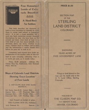
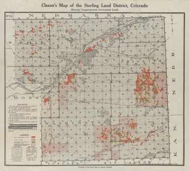
Name Display Form
Clason Map Co.
Title
Clason's map of the Sterling Land District, Colorado
Date Issued
1916
Name Display Form
Clason Map Co.
Title
Clason's map of the Sterling Land District, Colorado
Date Issued
1916
Name Display Form
[United States. Forest Service, Greeley, William B., 1879-1955, Kuphal, H. H., compiler]
Title
Cochetopa National Forest, Colorado : New Mexico principal meridian
Name Display Form
[United States. Forest Service, Greeley, William B., 1879-1955, Kuphal, H. H., compiler]
Title
Cochetopa National Forest, Colorado : New Mexico principal meridian
Name Display Form
[Greeley, William B., 1879-1955, Good, L. S., compiler]
Title
Cochetopa National Forest, Colorado : New Mexico principal meridian
Name Display Form
[Greeley, William B., 1879-1955, Good, L. S., compiler]
Title
Cochetopa National Forest, Colorado : New Mexico principal meridian
Name Display Form
[Greeley, William B., 1879-1955, Good, L. S., compiler]
Title
Cochetopa National Forest, Colorado : New Mexico principal meridian
Name Display Form
Geological Survey (U.S.)
Title
Colorado
Date Issued
[2001, 2001]
Name Display Form
Geographical Publishing Co.
Title
Colorado
Date Issued
1920/[1929]
Name Display Form
Mitchell, S. Augustus (Samuel Augustus), 1792-1868
Title
Colorado
Date Issued
1878
Title
Colorado
Date Issued
Circa 1885
Title
Colorado
Date Issued
Circa 1885
Name Display Form
O.W. Gray & Son
Title
Colorado and Kansas
Date Issued
Circa 1875
Name Display Form
O.W. Gray & Son
Title
Colorado and Kansas
Date Issued
Circa 1875
Name Display Form
[Colorado. Office of the State Engineer, Colorado. Division of Water Resources. Hydrographic Branch]
Title
Colorado historical average annual stream flows (acre feet)
Date Issued
2003
Name Display Form
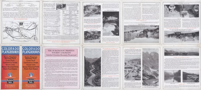
Chicago, Burlington & Quincy Railroad Company
Title
Colorado playgrounds : Rocky Mountain National Park, Estes Park, Continental Divide, Grand Lake, Denver Mountain Parks, Pike's Peak region
Date Issued
1922
Name Display Form
Chicago, Burlington & Quincy Railroad Company
Title
Colorado playgrounds : Rocky Mountain National Park, Estes Park, Continental Divide, Grand Lake, Denver Mountain Parks, Pike's Peak region
Date Issued
1922
Name Display Form
Colorado. Department of Highways. Planning and Research Division
Title
Colorado, 1964
Date Issued
1964
Name Display Form
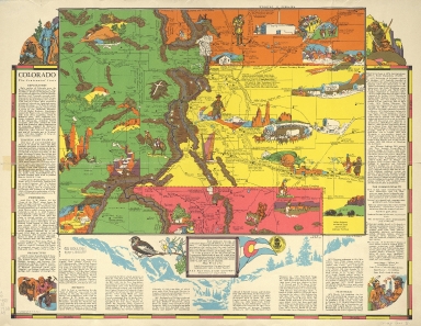
[Aitchison, R. T. (Robert T.), 1887-1964, Mentholatum Company]
Title
Colorado, the centennial state
Date Issued
1938
Name Display Form
Cram, George Franklin, 1841-1928
Title
Colorado; New Mexico
Date Issued
Between 1884 and 1887
Name Display Form
Cram, George Franklin, 1841-1928
Title
Colorado; New Mexico
Date Issued
Between 1884 and 1887
Title
Denver land district
Date Issued
1887/1889
|


![[Township no. 1 South, Range no. 71 West of the 6th Principal Meridian]](https://cudl.colorado.edu/MediaManager/srvr?mediafile=/Size3/CUB~13~13/4997/maps_coHistorical_southBoulderCreekSect_1888_B_d.jpg)
![[Township no. 1 South, Range no. 71 West of the 6th Principal Meridian] : [Boulder County, Colorado]](https://cudl.colorado.edu/MediaManager/srvr?mediafile=/Size3/CUB~13~13/4997/maps_coHistorical_southBoulderCreekSect_1888_A_d.jpg)