Detail View: Bent-Hyde Papers: Positions of various Indigenous "Soldier Societies" at the time of the Platte Bridge fight
|
File Name:
|
arbh13m1.tif
|
|
Collection Name:
|
Bent-Hyde Papers, 1905-1918
|
|
Collection Description:
|
This collection consists of original maps detailing locations of Indigenous nations in North America and military positions in areas such as Sand Creek and the Arkansas River. It includes correspondence between George Bent, a Cheyenne-American interpreter, George Hyde, a white historian, and George Grinnell, a white anthropologist while covering the years 1905-1918. In the interest of preserving and presenting the historical records, the University Libraries collects materials that document the perspectives presented by the creators. As a result, this collection contains objectionable depictions and language that do not reflect the current preferred terminology, or the values and norms of the University Libraries. CU Boulder Libraries acknowledges that it is located on the traditional territories and ancestral homelands of the Cheyenne, Arapaho, Ute and many other Native American nations. Their forced removal from these territories has caused devastating and lasting impacts. While the University of Colorado Boulder can never undo or rectify the devastation wrought on Indigenous peoples, we commit to improving and enhancing engagement with Indigenous peoples and issues locally and globally.
|
|
Work Title:
|
Positions of various Indigenous "Soldier Societies" at the time of the Platte Bridge fight
|
|
Alternative Title:
|
Map #13 Positions and movements of the soldier societies at Platte Bridge
|
|
Alternative Title Type:
|
proper (transcribed from "Fourteen original maps of George Bent and George Hyde by Jean Afton")
|
|
Work Agent Name:
|
Bent, George, 1843-1918
|
|
Work Agent Role:
|
author
|
|
Work Agent Name:
|
Hyde, George E., 1882-1968
|
|
Work Agent Role:
|
author
|
|
Work Date:
|
1905/1918
|
|
Work Date Type:
|
creation
|
|
Inscription Text:
|
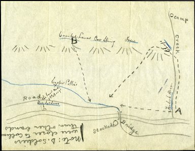
[Cataloger's note: Transcriptions come from a variety of resouces including legacy archival description and George Hyde's and George Grinnell's notes as documented by Jean Afton.] This rude sketch I sent to George Bent to have him indicate the position of the various Indian "Soldier societies" at the time of the charge of Lieut. Collins and his men at Platte Bridge. (Bent's writing is in ink, as follows) – 1. an X mark "Casper Collins" indicating the spot where Collins and his men were killed. 2. "Dog Soldiers, this band made first charge" marked south of Collins. (Should be further west —this band seems to have charged east, not north. 3. Behind the bluffs to the north: "Crooked Lances Bow Strings, Foxes, Chiefs." 4. to the east, at the mouth of a stream on which the Indians had their camp, "Foolish Dogs." The broken lines and arrows-points indicate the direction of the Indigenous charge. It will be seen that since the Dog soldiers charged east, Bent has either located Collins too far west along the road or has put the Dog Soldiers too far east. George E. Hyde
|
|
Subject Term:
|
Cheyenne Nation--History--Sources
|
|
Subject Term:
|
Tsistsistas-History--Sources
|
|
Subject Term:
|
Indigenous peoples--Colorado--Maps
|
|
Subject Term:
|
Platte Bridge, Battle of, Wyo., 1865--Maps
|
|
Subject Term:
|
Cheyenne Nation--Wars, 1865
|
|
Subject Term:
|
Colorado--History--To 1876--Maps
|
|
Work Description:
|
Drawing of map depicting positions of Indigenous "Soldier Societies" at the time of Platte Bridge Fight (1865).
|
|
Work Type:
|
sketch maps
|
|
Work Type:
|
Cartographic
|
|
Relation:
|
Fourteen Original Maps of George Bent and George Hyde by Jean Afton
|
|
Relation Type:
|
references
|
|
Relation Identifier:
|
arbh23.pdf
|
|
Relation href:
|
https://ark.colorado.edu/ark:/47540/46643z2807kv
|
|
Location Name:
|
University of Colorado Boulder Libraries Rare and Distinctive Collections
|
|
Location Type:
|
repository
|
|
Shelf Location:
|
Box 1 Folder 13
|
|
Image Rights:
|
The organization that has made the Item available believes that the Item is in the Public Domain under the laws of the United States, but a determination was not made as to its copyright status under the copyright laws of other countries. The Item may not be in the Public Domain under the laws of other countries. Please refer to the organization that has made the Item available for more information. URI: http://rightsstatements.org/vocab/NoC-US/1.0/
|
|
Image Source:
|
CU Boulder Online Finding Aid of Bent-Hyde Papers, 1820-1918
|
|
Image Measurement:
|
101000000
|
|
Image Measurement Type:
|
fileSize
|
|
Image Measurement Unit:
|
bytes
|
|
Image Work Type:
|
reformatted digital
|
|
Identifier ARK:
|
https://ark.colorado.edu/ark:/47540/nx6t3791d36s
|