Detail View: Colorado Historical Maps: Clason's map of the Sterling Land District, Colorado
|
Collection Name:
|
Colorado Historical Maps
|
|
Title:
|
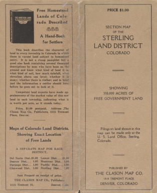
Clason's map of the Sterling Land District, Colorado
|
|
Subtitle:
|
Showing unappropriated government lands
|
|
Alternative Title:
|
Section map of the Sterling Land District, Colorado : showing 350,000 acres of free government land
|
|
Alternative Title:
|
Sterling Land District, Colorado
|
|
Name Display Form:
|
Clason Map Co.
|
|
Genre:
|
map
|
|
Genre Authority:
|
http://id.loc.gov/vocabulary/marcgt/map
|
|
Place Term:
|
Denver (Colo.)
|
|
Publisher:
|
Clason Map Company
|
|
Date Issued:
|
1916
|
|
Language Term:
|
English
|
|
Form:
|
cartographic material
|
|
Extent:
|
1 map : color ; 43 x 50 cm
|
|
Note:
|
Shows railroad lines and natural water features. Shows all or part of the following counties: Weld, Logan, Sedgwick, Phillips, Morgan, Washington, and Yuma
|
|
Note:
|
Township and range grid
|
|
Note:
|
Text explains land survey system
|
|
Note:
|
CU Libraries copy has three of the last 5 five lines of text blacked out under Explanation section
|
|
Note:
|
Map Library instruction
|
|
Subject Topic:
|
Public lands--Colorado--Logan County--Maps
|
|
Subject Topic:
|
Public lands
|
|
Subject Topic:
|
Public lands--Colorado--Weld County--Maps
|
|
Subject Topic:
|
Public lands--Colorado--Sedgwick County--Maps
|
|
Subject Topic:
|
Public lands--Colorado--Yuma County--Maps
|
|
Subject Topic:
|
Public lands--Colorado--Morgan County--Maps
|
|
Subject Topic:
|
Public lands--Colorado--Washington County--Maps
|
|
Subject Topic:
|
Public lands--Colorado--Maps
|
|
Subject Topic:
|
Public lands--Colorado, Northeastern--Maps
|
|
Subject Geographic:
|
Colorado (United States, North America) (first order administrative divisions)
|
|
Subject Genre:
|
Maps
|
|
Subject Cartographics Scale:
|
Scale approximately 1:66,000
|
|
Subject Cartographics Coordinates:
|
(W 104°--W 102°/N 41°--N 39°24ʹ38ʺ)
|
|
Identifier ARK:
|
https://ark.colorado.edu/ark:/47540/c7919q44q9hv
|
|
Identifier:
|
maps_coHistorical_1916_ClasonsSterlingLand.jp2
|
|
Physical Location:
|
For more information about the physical collection, visit the Jerry Crail Johnson Earth Sciences & Map Library
|
|
Shelf Identifier:
|
G4311 .G5 1916 .C5
|
|
Rights:
|
The organization that has made the Item available believes that the Item is in the Public Domain under the laws of the United States, but a determination was not made as to its copyright status under the copyright laws of other countries. The Item may not be in the Public Domain under the laws of other countries. Please refer to the organization that has made the Item available for more information. URI: http://rightsstatements.org/vocab/NoC-US/1.0/
|