Detail View: Colorado Historical Maps: Greeley and additions
|
Collection Name:
|
Colorado Historical Maps
|
|
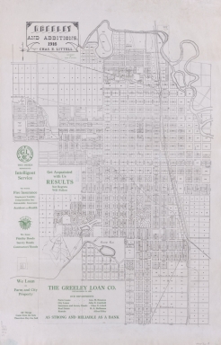
Title:
|
Greeley and additions
|
|
Genre:
|
map
|
|
Genre Authority:
|
http://id.loc.gov/vocabulary/marcgt/map
|
|
Place Term:
|
[Colorado]
|
|
Publisher:
|
[publisher not identified]
|
|
Date Issued:
|
1916
|
|
Language Term:
|
English
|
|
Form:
|
Cartographic materials
|
|
Extent:
|
1 map ; 76 x 51 cm, on sheet 87 x 56 cm
|
|
Note:
|
Shows additions and some block numbers
|
|
Note:
|
Distributed by The Greeley Loan Co. with text advertising the company in margins in green ink
|
|
Subject Topic:
|
Greeley (Colo.) -- Maps
|
|
Subject Geographic:
|
Greeley (Weld, Colorado, United States, North America) (populated place)
|
|
Subject Genre:
|
Maps
|
|
Subject Cartographics Scale:
|
Scale 1:2400. 1 in. = 200 ft.
|
|
Subject Cartographics Coordinates:
|
W 104°43'10"--W 104°40'40"/N 40°26'05"--N 40°23'30"
|
|
Identifier ARK:
|
https://ark.colorado.edu/ark:/47540/fq7h7926010p
|
|
Identifier:
|
maps_coHistorical_greeleyLittell1916_d.jp2
|
|
Physical Location:
|
For more information about the physical collection, visit the Jerry Crail Johnson Earth Sciences & Map Library
|
|
Shelf Identifier:
|
G4314.G8G46 1916 .L5
|
|
Rights:
|
The organization that has made the Item available believes that the Item is in the Public Domain under the laws of the United States, but a determination was not made as to its copyright status under the copyright laws of other countries. The Item may not be in the Public Domain under the laws of other countries. Please refer to the organization that has made the Item available for more information. http://rightsstatements.org/vocab/NoC-US/1.0/
|