Detail View: Archivision Base to Module 9: Lost Dutchman State Park: Topographic Views
|
Preferred Title:
|
Lost Dutchman State Park: Topographic Views
|
|
Image View:
|
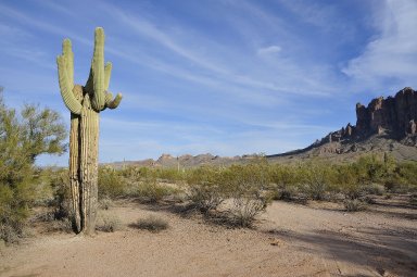
Desert butte in the Superstition Mountains; saguaro cactus (Carnegiea gigantea) at left
|
|
Creator:
|
Scott Gilchrist (Canadian photographer, born 1960)
|
|
Location:
|
creation: Apache Junction, Arizona, United States
|
|
Location Note:
|
Pinal County; junction of the Apache Trail and U.S. Route 60
|
|
GPS:
|
+33.456111-111.476667
|
|
Date:
|
photographed 2012 (creation)
|
|
Cultural Context:
|
American
|
|
Style Period:
|
Twenty-first century
|
|
Work Type 1:
|
topographical view
|
|
Work Type 2:
|
photograph
|
|
Classification:
|
urban and topographical views
|
|
Material:
|
digital images
|
|
Technique:
|
photography
|
|
Description:
|
Lost Dutchman State Park is a 320-acre (129 ha) state park located near the Superstition Mountains in central Arizona, and named after the Lost Dutchman's Gold Mine, a famous gold mine legendary among the tales of the Old West. The park also acts as a trailhead for the trails leading into the Tonto National Forest in which the Superstition Mountains (and the Lost Dutchman mine) are located. (Source: Wikipedia; http://en.wikipedia.org/wiki/Main_Page)
|
|
Collection:
|
Archivision Addition Module Nine
|
|
Identifier:
|
2A2-US-SP-LD-A03
|
|
Rights:
|
© Scott Gilchrist, Archivision, Inc.
|