Detail View: Archivision Base to Module 9: Arches National Park: Topographic Views
|
Preferred Title:
|
Arches National Park: Topographic Views
|
|
Image View:
|
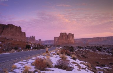
Near Moab, view along the park road in the Courthouse Towers section
|
|
Location:
|
creation: Utah, United States
|
|
Date:
|
ca. 2001 (photographed)
|
|
Cultural Context:
|
American
|
|
Work Type 1:
|
topographical view
|
|
Work Type 2:
|
photograph
|
|
Classification:
|
urban and topographical views
|
|
Technique:
|
photography
|
|
Subjects:
|
contemporary (1960 to present); landscapes; parks (recreation areas); rock formation
|
|
Description:
|
Arches National Park preserves over 2,000 natural sandstone arches, including the world-famous Delicate Arch, in addition to a variety of unique geological resources and formations. The park is located near Moab, Utah, and is 119 square miles (309 square km) in size. Its highest elevation is 5,653 feet (1,723 m) at Elephant Butte and its lowest elevation is 4,085 feet (1,245 m) at the visitor center. Since 1970, 42 arches have toppled because of erosion. Arches National Park receives 10 inches (250 mm) of rain a year on average. The area, administered by the National Park Service, was originally designated as a national monument on April 12, 1929. It was redesignated a national park on November 12, 1971. More than 833,000 people visited it in 2006. (Source: Wikipedia; http://en.wikipedia.org/wiki/Main_Page)
|
|
Collection:
|
Archivision Base Collection
|
|
Identifier:
|
2A2-US-NP-AP-C1
|
|
Rights:
|
© Scott Gilchrist, Archivision, Inc.
|