Detail View: Archivision Base to Module 9: Savannah: Topographic Views of the City Squares
|
Preferred Title:
|
Savannah: Topographic Views of the City Squares
|
|
Image View:
|
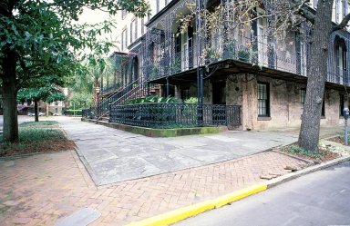
View of town home (row house) with ironwork verandah, at corner
|
|
Location:
|
creation: Savannah, Georgia, United States
|
|
Location Note:
|
GPS for Historic District, south (Forsyth Park)
|
|
GPS:
|
+32.069282-81.095549
|
|
Date:
|
May 1997 (photographed)
|
|
Cultural Context:
|
American
|
|
Work Type 1:
|
topographical view
|
|
Work Type 2:
|
photograph
|
|
Classification:
|
urban and topographical views
|
|
Material:
|
photographs; digital images
|
|
Technique:
|
photography
|
|
Subjects:
|
architecture; cityscape; City planning; antebellum architecture
|
|
Description:
|
James Oglethorpe, a military officer, led the first group of settlers to Georgia and founded Savannah in 1733, as a debtors' haven and buffer to Spanish Florida. He probably drew up the town?s distinctive urban plan, perhaps in association with other trustees. Unlike traditional new towns, Savannah was given no central square, no single hierarchical pattern and no boundary. Instead, it was based on an indefinitely extendable grid of ?wards?, each measuring 600 ft sq. (c. 183 m sq.), focused on its own square and comprising sectors for public and private buildings and a diversity of street types. Four such wards were set out in 1733, and two more added in the following year. By 1851 there were twenty-four squares in the city; many contain monuments, markers, memorials, statues, plaques, and other tributes. (Source: Grove Art Online; http://www.oxfordartonline.com/)
|
|
Collection:
|
Archivision Addition Module Six
|
|
Identifier:
|
1B3-AB-S-G2
|
|
Rights:
|
© Scott Gilchrist, Archivision, Inc.
|