Detail View: Bent-Hyde Papers: Sand Creek Area
|
File Name:
|
arbh10m.tif
|
|
Collection Name:
|
Bent-Hyde Papers, 1905-1918
|
|
Collection Description:
|
The collection consists of original maps of Indian and military positions of such areas as Sand Creek, the Arkansas River, etc., and correspondence between George Bent and George Hyde, covering the years 1905-1918.
|
|
Work Title:
|
Sand Creek Area
|
|
Work Agent Name:
|
Bent, George, 1843-1918
|
|
Work Agent Role:
|
author
|
|
Work Agent Name:
|
Hyde, George E., 1882-1968
|
|
Work Agent Role:
|
author
|
|
Work Date:
|
1905/1918
|
|
Work Date Type:
|
creation
|
|
Inscription Text:
|
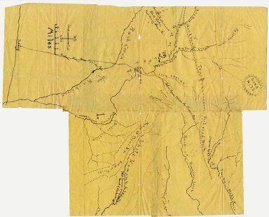
I sent this sketch map to Bent to get him to locate on it certain places mentioned in his narrative. He noted, with pen and ink, the following items --- 1. Southwest corner of map: Ft. Lyon and "Indian trail made by Lodge Poles" running from the fort n-e across Sand Creek and on to the head of Smoky Hill river. 2. "Battle Sand Creek 1864" on Sand Creek at the point where the trail crosses. 3. At west edge of map near upper Rush Creek; "Fine spring here of Water ran into Black Lakes. Wild Horses ranged here." The Black Lakes were where the Cheyennes went to run wild horses about 1828, 100 years ago. The lake, or lakes, are often mentioned in the Cheyennes stories about wild horses and about Bull Hump the Comanche chief. 4. On White Woman's Creek in southeast corner: "White Woman was Captured Mouth of this Creek 1868." He told me that was how the creek got its name. 5. The points on Sand Creek where running water is marked are numbered L and 2. I suggested to Bent that one of these points was the location of Black Kettle's camp; but he said no and marked the camp where shown on the map. George E. Hyde. October, 1928.
|
|
Subject Term:
|
Cheyenne Indians--History--Sources
|
|
Subject Term:
|
Indians of North America--Colorado--Maps
|
|
Subject Term:
|
Sand Creek Massacre, Colo., 1864
|
|
Subject Term:
|
Cheyenne Indians--Wars, 1864
|
|
Subject Term:
|
Colorado--History--To 1876--Maps
|
|
Work Description:
|
Drawing of map depicting the Sand Creek Area 1864-1868, including the Battle of Sand Creek and Indian trails.
|
|
Work Type:
|
sketch maps
|
|
Location Name:
|
University of Colorado Boulder Libraries Rare and Distinctive Collections
|
|
Location Type:
|
repository
|
|
Location Refid:
|
Box 1 Folder 10
|
|
Location Refid Type:
|
shelfList
|
|
Image Rights:
|
The organization that has made the Item available believes that the Item is in the Public Domain under the laws of the United States, but a determination was not made as to its copyright status under the copyright laws of other countries. The Item may not be in the Public Domain under the laws of other countries. Please refer to the organization that has made the Item available for more information. URI: http://rightsstatements.org/vocab/NoC-US/1.0/
|
|
Image Source:
|
CU Boulder ArchivesSpace Online Finding Aid of Bent-Hyde Papers, 1820-1918
|
|
Image Source Refid:
|
https://archives.colorado.edu/repositories/2/resources/33
|
|
Image Measurement:
|
1.32E+08
|
|
Image Measurement Type:
|
fileSize
|
|
Image Measurement Unit:
|
bytes
|
|
Image Work Type:
|
digital images
|
|
Identifier ARK:
|
https://ark.colorado.edu/ark:/47540/r61s2h8973jf
|